 http://www.nps.gov/lyjo/naturescience/naturalfeaturesandecosystems.htm
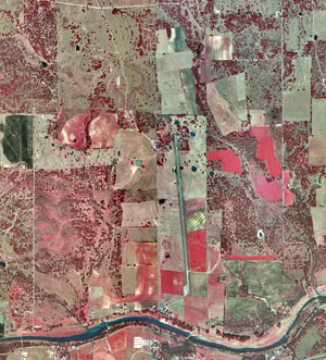
This is an aerial infrared photo of the Lyndon B. Johnson National Park. This park is located in Stonewall, Texas. Notice the healthier the plants the brighter the red is. This is due to the fact that the red gun is set for the near infrared range. This is the region of the Electromagnetic spectrum that vegetation reflect the most in.This map is an infrared photo because the satellite is sensing in the near infrared range of the magnetic spectrum. Enjoy!!!
No problem!! I am taking a class in remote sensing right now so that's how I learned that information.
ReplyDelete